Kansas City Metro
Drone Imagery & Visual Orthomosaics
Clear aerial documentation for construction, aggregate, land, and property projects—captured with an RTK-capable platform and scoped for visual use.
Visual Deliverables
Choose high-resolution aerial photos, a stitched visual orthomosaic, recurring progress imagery, or a project-specific image set. Deliverables are defined in writing before the flight.
For Earthwork & Site Contractors
Give owners, estimators, and field teams a current visual record of site conditions and progress.
- ✓Current aerial context for preconstruction conversations
- ✓Repeatable progress imagery for owners and clients
- ✓Before-and-after documentation from consistent viewpoints
- ✓Visual records for meetings, reports, and closeout packages
- ✓Raw imagery capture coordinated with your licensed project team
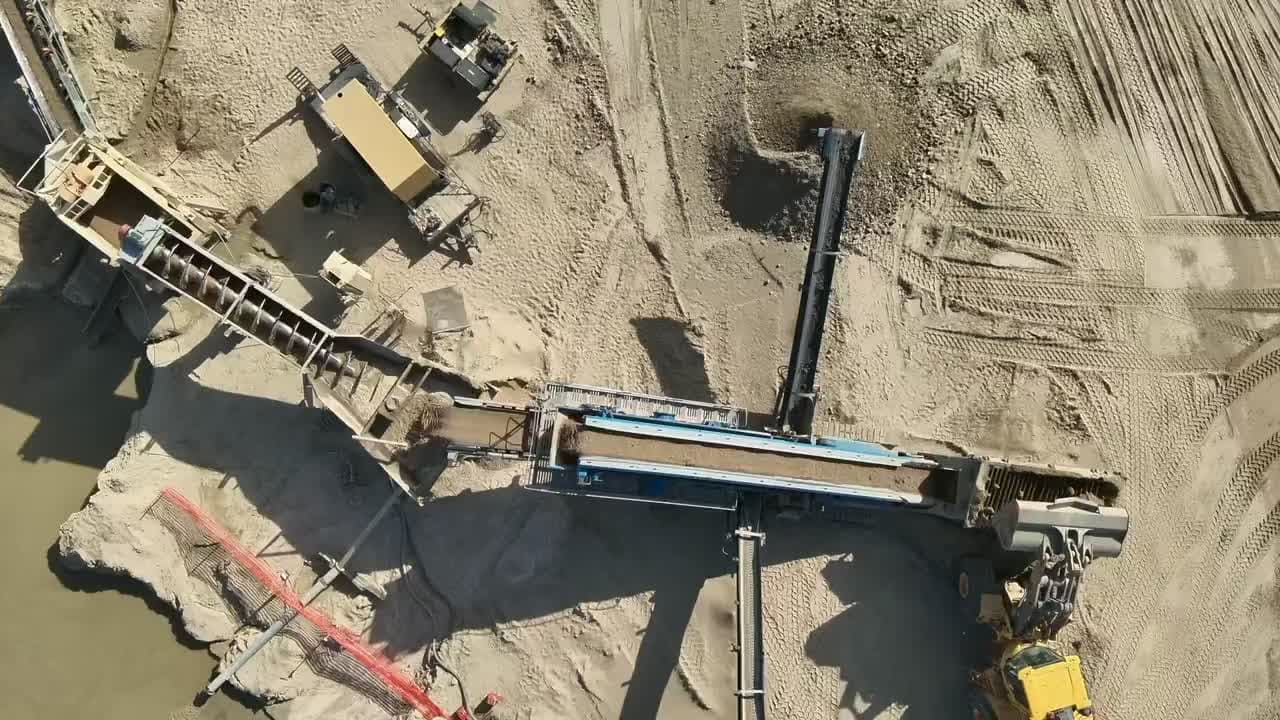
For Quarry & Pit Operators
Build a consistent visual history of work areas, site changes, and material operations.
- ✓High-resolution site overview imagery
- ✓Recurring visual records of changing work areas
- ✓Marketing-ready aerial photo and video options
- ✓Consistent flight plans for visual comparisons
- ✓Data capture support for a PLS, PE, or GIS lead
How It Works
Schedule
Book your flight window. We coordinate timing around weather and your project schedule.
Capture
We capture the agreed imagery with an RTK-capable drone and GNSS base/rover tools when the scope calls for them, subject to weather, access, and airspace requirements.
Process
We process the imagery into the visual products defined in the written scope, with project-specific quality checks.
Deliver
Receive the agreed image set, visual orthomosaic, or source imagery through a clear digital handoff.
Built To Support Licensed Project Teams
When a project crosses into surveying or engineering, the licensed professional must lead the scope, establish the controls and standards, and remain responsible for the professional work.
Public Scope Available Now
Our direct visual-documentation services include:
- High-resolution aerial photography
- Visual orthomosaic imagery
- Progress and before/after documentation
- Marketing photo and video
Licensed Scope Required
Contact a qualified PLS or PE for work involving:
- Property boundaries or real-property rights
- Coordinates, elevations, contours, or control
- Volumes, cut/fill, drainage, or design decisions
- Certified or regulatory deliverables
Licensed-Team Collaboration
When requested by the licensed lead:
- They define the intended use and written scope
- They specify controls, checks, formats, and tolerances
- We discuss acquisition support under their direction
- No certification or accuracy is implied by equipment alone
Frequently Asked Questions
Is this a land survey?
No. FlintEdge Stone is not a licensed land surveying firm. Our public aerial service provides photography and visual documentation only. It does not establish boundaries, elevations, coordinates, contours, quantities, or other survey or engineering results.
Can you provide measurements, contours, or volume calculations?
Those scopes are not offered as standalone public services. If a project needs coordinates, elevations, contours, quantities, cut/fill, drainage, boundary work, or other professional conclusions, an appropriately licensed PLS or PE must lead and define the work. We can discuss imagery or acquisition support directly with that licensed professional.
What size sites can you map?
We can photograph sites from a few acres to larger multi-flight properties. Feasibility depends on airspace, access, weather, battery logistics, and the requested image coverage. Send the location and intended use for a project-specific quote.
Does RTK equipment make the imagery survey-grade?
No. RTK-capable equipment can improve positioning during acquisition, but equipment specifications are not a project accuracy statement. Accuracy depends on the full workflow, controls, conditions, processing, and independent verification. We do not advertise a fixed accuracy or represent our visual deliverables as survey-grade.
What is a visual orthomosaic?
It is a stitched overhead image assembled from many drone photographs. It can be useful for visual documentation and communication, but our public orthomosaic product is not a land survey, design drawing, boundary map, or certified measurement product.
How long until I receive my data?
Turnaround is confirmed in the quote and depends on site size, weather, airspace, flight complexity, and the requested deliverables. Recurring projects can be scheduled around an agreed reporting cadence.
Do you fly in bad weather?
Flights require suitable visibility, wind, precipitation, site, and airspace conditions. If conditions are not safe or lawful, we reschedule the flight window.
Can you provide recurring flights?
Yes. Monthly, quarterly, milestone, and before-and-after flights are available for visual progress records. We agree on viewpoints, coverage, and delivery cadence before the first flight.
Need A Clearer View Of Your Site?
Send the Kansas City-area location, approximate acreage, intended use, and preferred timing.
Contact us online: Contact form
FlintEdge Stone is not a licensed professional land surveying or engineering firm. Public aerial deliverables are visual documentation only and must not be used to establish boundaries, elevations, coordinates, contours, quantities, drainage, design, or other professional conclusions. Engage an appropriately licensed PLS or PE for those purposes.